
Hurricane Isaias was intensifying early Thursday and is expected to make landfall along the U.S. Gulf Coast late Friday or early Saturday, threatening parts of Mississippi, Alabama and the western part of the Florida Panhandle. It became the first hurricane of the 2026 Atlantic season after strengthening from a tropical storm late Wednesday night.
A hurricane warning is in effect for the northern Gulf Coast, from Ocean Springs, Mississippi, across Alabama to Florida’s Bay/Gulf County line.
Florida Gov. Ron DeSantis declared a state of emergency for more than two dozen counties in his state, and Alabama Gov. Kay Ivey issued a state of emergency for 40 counties.
Maps show hurricane’s path
Isaias, pronounced “ees-ah-EE-ahs,” had maximum sustained winds of 80 mph early Thursday and its core was located about 420 miles south-southwest of the mouth of the Mississippi River, according to the National Hurricane Center.
“Additional strengthening is expected through early Friday, and Isaias should remain a strong hurricane as it approaches the northern Gulf Coast on Friday night,” the center said.
“Preparations to protect life and property from storm surge and damaging winds along the warning area of the Gulf Coast should be rushed to completion today,” the Miami-based center stressed.
Along with the hurricane warning, a tropical storm warning was issued from Louisiana’s Jefferson/Plaquemines Parish line to west of Ocean Springs, Mississippi and from east of the Bay/Gulf County line to Florida’s Aucilla River. A storm surge warning was issued from the mouth of the Mississippi River to the Steinhatchee River in Florida.
CBS News 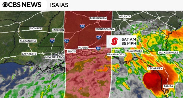
The hurricane center forecasts 3 to 7 inches of rain and as much as 10 inches in some places along the coast from southeastern Louisiana to the Florida Panhandle. Much of the Southeast, and as far north as the Tennessee Valley and the Carolinas, could see heavy rainfall.
The latest for a first hurricane since 1905
Isaias’ progression into a hurricane on Wednesday marked the latest date in 121 years for the Atlantic season’s first hurricane to develop, just missing a record set on Oct. 8, 1905, according to National Oceanic and Atmospheric Administration data.
The season, which has been unusually quiet in the Atlantic this year, runs from June 1 through Nov. 30.
An Atlantic hurricane season typically produces, on average, 14 named storms, seven hurricanes and three major hurricanes, according to the hurricane center, which used climate data collected between 1991 and 2020 to calculate those figures. A season’s first named storm normally forms in mid- to late-June, while the first hurricane tends to form in early- to mid-August, and the first major hurricane often comes in late August or early September.
Forecasters predicted there would be less Atlantic storm activity than usual this year, but so far it has been even quieter than anticipated. Meteorologists say that’s largely due to to the onset of a strong El Niño over the summer, which typically correlates with cooler water temperatures and greater fluctuations in wind patterns over the Atlantic, conditions that dampen the growth of tropical systems. The Pacific, meanwhile, has seen an unusually active series of hurricanes.